PAIR 1
Old Tokyo
Sensō-ji → Ueno Park
Take a transport break between Asakusa and Ueno; choose one temple or museum visit.
THE ILLUSTRATED CITY COLLECTION
Our top eight sightseeing picks for each of six cities, grouped into four flexible pairs. This is an editorial selection, not a visitor ranking. Pick a neighbourhood, leave room for a pause, and make the day your own.
These are flexible ideas, not a timed tour. Map dots are plotted from checked geographic coordinates, with north up and a distance scale. Large parks and districts use named reference points, not entrances. Check opening days, tickets and access before setting out.
Explore city food maps → · Premier League club & city map →
TOP 8 · YOUR PACE
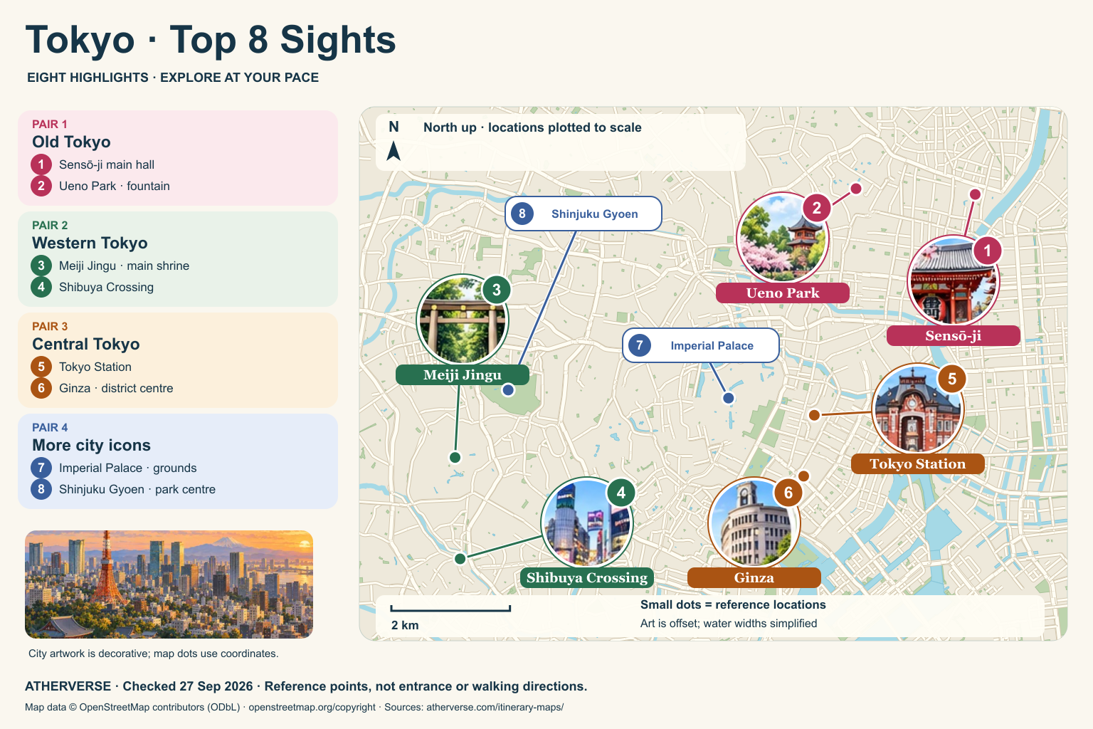
PAIR 1
Sensō-ji → Ueno Park
Take a transport break between Asakusa and Ueno; choose one temple or museum visit.
PAIR 2
Meiji Jingu → Shibuya Crossing
Allow time for the shrine grounds before the busy crossing.
PAIR 3
Tokyo Station → Ginza
Explore the station exterior and Ginza at your own pace.
PAIR 4
Imperial Palace → Shinjuku Gyoen
Add these highlights at your own pace; check each venue’s current access, admission and opening times.
North up. Ueno Park’s fountain is west and slightly north of Sensō-ji’s main hall. Meiji Jingu lies almost directly north of Shibuya Crossing. Tokyo Station is northeast of both; Ginza’s district reference point is south of the station. The Imperial Palace grounds reference is west of Tokyo Station; Shinjuku Gyoen is farther west, northeast of Meiji Jingu.
Small dots use a local geographic projection with equal horizontal and vertical distance scales. Numbered labels are moved only for readability; their thin leader lines point to the location. Park and district points are representative, not confirmed entrances. The background shows selected streets, parks and water from OpenStreetMap. River widths are simplified. Illustrated landmark circles are decorative, and the map is not for turn-by-turn navigation.
Source points checked 27 September 2026. © OpenStreetMap contributors · ODbL. Ueno’s fountain also uses the official park guide; Pincio Terrace is cross-checked with Apple Maps.
TOP 8 · YOUR PACE
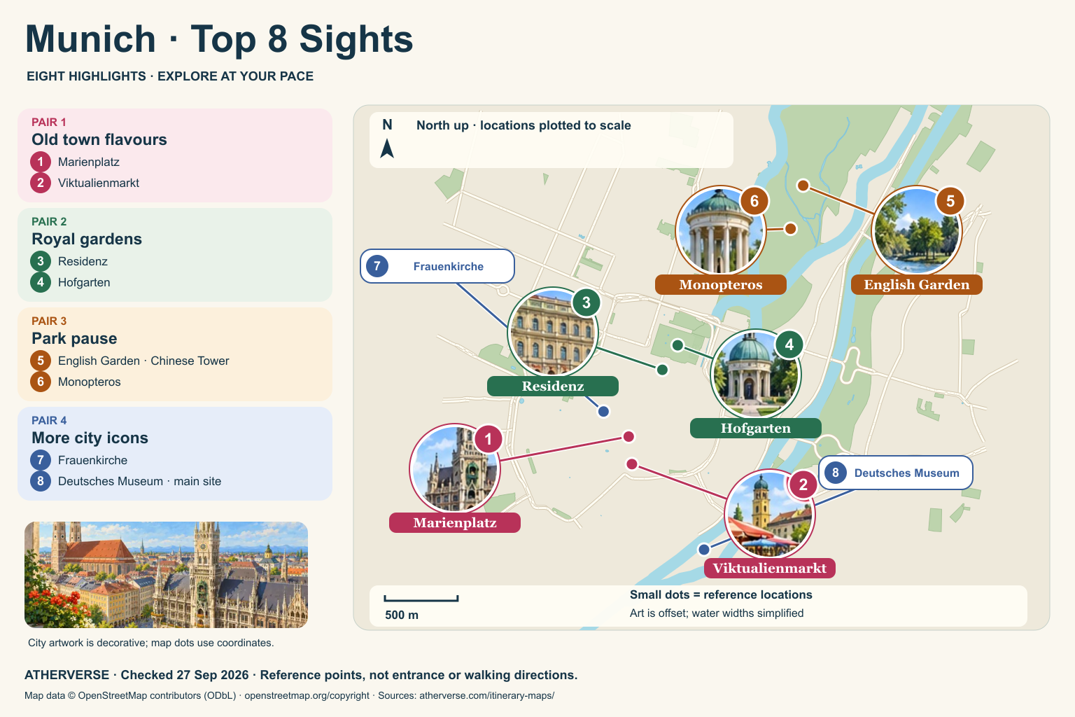
PAIR 1
Marienplatz → Viktualienmarkt
Explore the square, then choose a market snack.
PAIR 2
Residenz → Hofgarten
Choose a palace visit or garden pause; interiors need separate planning.
PAIR 3
English Garden → Monopteros
Keep to a short park loop. The Monopteros viewpoint involves a hill and steps.
PAIR 4
Frauenkirche → Deutsches Museum
Add these highlights at your own pace; check each venue’s current access, admission and opening times.
North up. Viktualienmarkt is just south of Marienplatz. The Residenz and Hofgarten lie to the northeast. The English Garden reference point is the Chinese Tower; Monopteros is southwest of that tower, within the same park. Frauenkirche is northwest of Marienplatz. The Deutsches Museum main site is southeast of the old town on Museum Island.
Small dots use a local geographic projection with equal horizontal and vertical distance scales. Numbered labels are moved only for readability; their thin leader lines point to the location. Park and district points are representative, not confirmed entrances. The background shows selected streets, parks and water from OpenStreetMap. River widths are simplified. Illustrated landmark circles are decorative, and the map is not for turn-by-turn navigation.
Source points checked 27 September 2026. © OpenStreetMap contributors · ODbL. Ueno’s fountain also uses the official park guide; Pincio Terrace is cross-checked with Apple Maps.
TOP 8 · YOUR PACE
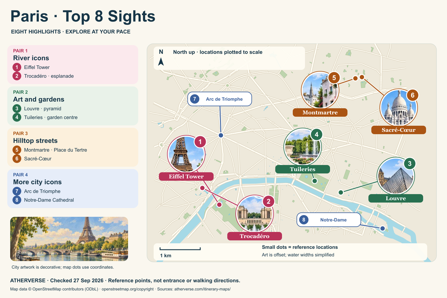
PAIR 1
Eiffel Tower → Trocadéro
Enjoy exterior views; reserve tower entry separately if wanted.
PAIR 2
Louvre → Tuileries
Choose a small part of the Louvre, then rest in the gardens.
PAIR 3
Montmartre → Sacré-Cœur
Expect slopes and steps; check a suitable access route before going.
PAIR 4
Arc de Triomphe → Notre-Dame
Add these highlights at your own pace; check each venue’s current access, admission and opening times.
North up. Trocadéro is northwest of the Eiffel Tower. The Louvre is east and slightly north of the tower, with the Tuileries northwest of the Louvre. Montmartre is represented by Place du Tertre, just west of Sacré-Cœur; both are north of the Louvre. The Arc de Triomphe is north of the Eiffel Tower. Notre-Dame is southeast of the Louvre on Île de la Cité.
Small dots use a local geographic projection with equal horizontal and vertical distance scales. Numbered labels are moved only for readability; their thin leader lines point to the location. Park and district points are representative, not confirmed entrances. The background shows selected streets, parks and water from OpenStreetMap. River widths are simplified. Illustrated landmark circles are decorative, and the map is not for turn-by-turn navigation.
Source points checked 27 September 2026. © OpenStreetMap contributors · ODbL. Ueno’s fountain also uses the official park guide; Pincio Terrace is cross-checked with Apple Maps.
TOP 8 · YOUR PACE
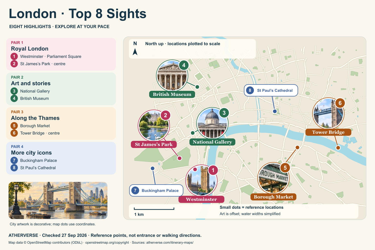
PAIR 1
Westminster → St James’s Park
Choose exterior views or book a visit, then pause in the park.
PAIR 2
National Gallery → British Museum
Pick a small collection in each museum, or choose just one.
PAIR 3
Borough Market → Tower Bridge
Take a market break before continuing toward the bridge.
PAIR 4
Buckingham Palace → St Paul’s Cathedral
Add these highlights at your own pace; check each venue’s current access, admission and opening times.
North up. Westminster is represented by Parliament Square. St James’s Park is northwest of it. The National Gallery and British Museum are farther north. Borough Market and Tower Bridge are to the east, with the bridge almost due east of the market. Buckingham Palace is west of Parliament Square. St Paul’s Cathedral is northeast of the National Gallery.
Small dots use a local geographic projection with equal horizontal and vertical distance scales. Numbered labels are moved only for readability; their thin leader lines point to the location. Park and district points are representative, not confirmed entrances. The background shows selected streets, parks and water from OpenStreetMap. River widths are simplified. Illustrated landmark circles are decorative, and the map is not for turn-by-turn navigation.
Source points checked 27 September 2026. © OpenStreetMap contributors · ODbL. Ueno’s fountain also uses the official park guide; Pincio Terrace is cross-checked with Apple Maps.
TOP 8 · YOUR PACE
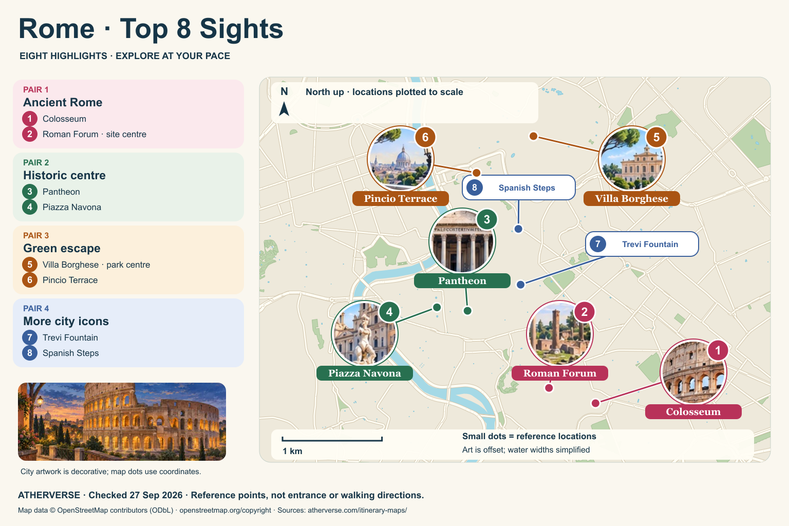
PAIR 1
Colosseum → Roman Forum
Book archaeological entry ahead where needed; uneven surfaces can be tiring.
PAIR 2
Pantheon → Piazza Navona
Allow space for a café break between the monument and square.
PAIR 3
Villa Borghese → Pincio Terrace
Choose a short garden outing; check the slope and step conditions to the terrace.
PAIR 4
Trevi Fountain → Spanish Steps
Add these highlights at your own pace; check each venue’s current access, admission and opening times.
North up. The Roman Forum is northwest of the Colosseum. The Pantheon and Piazza Navona lie farther northwest; Navona is just west of the Pantheon. Villa Borghese’s park reference point is northeast of the Pincio Terrace, both north of the historic centre. Trevi Fountain is northeast of the Pantheon. The Spanish Steps are almost directly north of the fountain.
Small dots use a local geographic projection with equal horizontal and vertical distance scales. Numbered labels are moved only for readability; their thin leader lines point to the location. Park and district points are representative, not confirmed entrances. The background shows selected streets, parks and water from OpenStreetMap. River widths are simplified. Illustrated landmark circles are decorative, and the map is not for turn-by-turn navigation.
Source points checked 27 September 2026. © OpenStreetMap contributors · ODbL. Ueno’s fountain also uses the official park guide; Pincio Terrace is cross-checked with Apple Maps.
TOP 8 · YOUR PACE
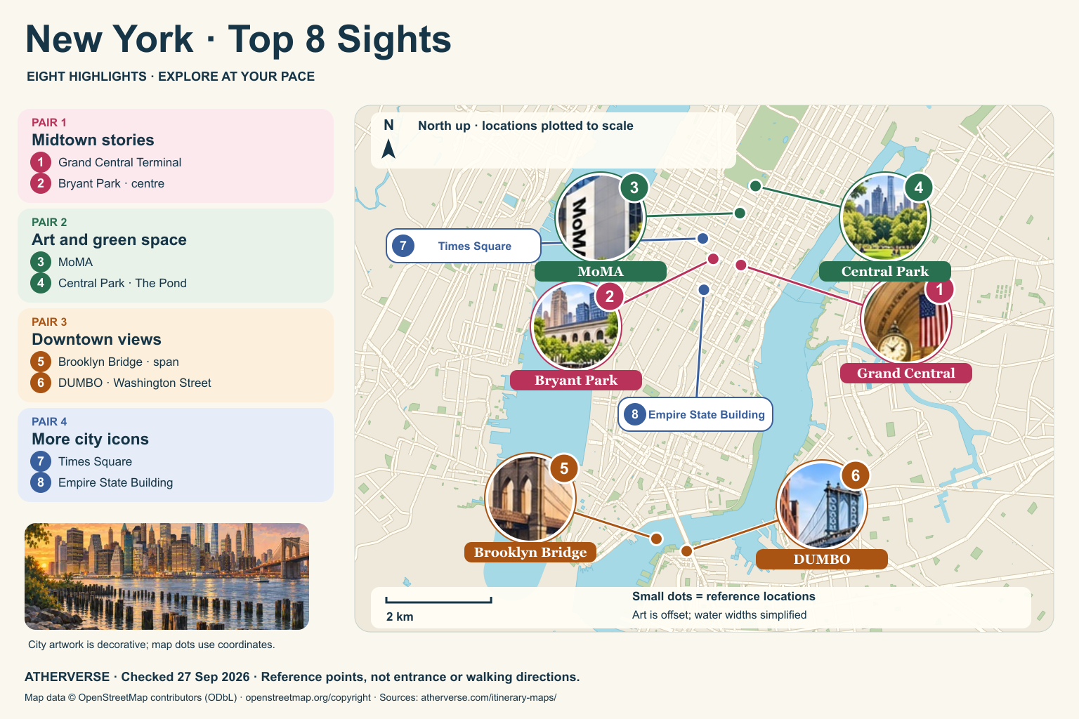
PAIR 1
Grand Central → Bryant Park
Enjoy the terminal architecture, then rest in the park.
PAIR 2
MoMA → Central Park
Choose a focused museum visit before a short park outing.
PAIR 3
Brooklyn Bridge → DUMBO
Bridge walking can be crowded and exposed; consider transport to Brooklyn if preferred.
PAIR 4
Times Square → Empire State Building
Add these highlights at your own pace; check each venue’s current access, admission and opening times.
North up. Bryant Park is west and slightly north of Grand Central. MoMA is almost due north of Grand Central. Central Park is represented by The Pond at its southeast corner, northeast of MoMA. Brooklyn Bridge and DUMBO are several kilometres south; Washington Street in DUMBO is southeast of the bridge reference point. Times Square is northwest of Bryant Park; the Empire State Building is south of Bryant Park.
Small dots use a local geographic projection with equal horizontal and vertical distance scales. Numbered labels are moved only for readability; their thin leader lines point to the location. Park and district points are representative, not confirmed entrances. The background shows selected streets, parks and water from OpenStreetMap. River widths are simplified. Illustrated landmark circles are decorative, and the map is not for turn-by-turn navigation.
Source points checked 27 September 2026. © OpenStreetMap contributors · ODbL. Ueno’s fountain also uses the official park guide; Pincio Terrace is cross-checked with Apple Maps.